| Hayti, Mo |
It’s interesting the things you find when you travel.
For example, I’m writing this from a booth, at dinner, in what appears to be an authentic Mexican restaurant in rural southern Missouri. Now to be fair, I haven’t tried the food yet, but I’m sitting by the kitchen and judging by the dishes flowing out of that kitchen, early returns are promising.
It’s been a very interesting last 30 hours or so. Waking up in Asheville, NC, proceeding up into the Smoky Mountains of Tennessee, a rather eventful hike on Mt. LeConte, then traveling the length of the state, hopping the Mississippi River and now concluding with the aforementioned pleasant find for dinner.
Just a day in the life…
Mt. LeConte is the 6th highest peak east of the Mississippi River; less than 100 feet short of the 1st place finisher Mt. Mitchell.
It’s in the heart of the Smoky Mountains, off the Blue Ridge Parkway and a little bit south of Gaitlinburg, TN, where I had one of the more surreal experiences of my life yesterday, and we’ll talk about that in a little bit too.
After a thoroughly pleasant lunch with my long lost friend George, I set out for the Smokies and they didn’t disappoint.
Take my description of the Blue Ridge Parkway in North Carolina, throw in quite a few more mountain tunnels, amp up the roller coaster roadways by a factor of two, change the state to Tennessee and there you have it. In short, it’s awe inspiring and an awful pretty thing to look at.
Unfortunately my looky-loo’ness put me way behind schedule and I didn’t get to the trailhead until 4:00pm. Which was the first of several silly and quite frankly, inexcusable mistakes that led me to within a whisker of needing to hunker down for the night on the trail back down from the summit.
When hiking solo, there are some rather basic rules that one should observe and while I observed some of them, I didn’t observe them all. And these are the sorts of rules, that should you break them, can put you in a really bad spot – as I put myself – or in a worst case scenario, seriously injure or kill you.
Curious thing is that I’m not quite sure how I screwed up. I’m not a master mountain man, but I am pretty experienced. I’ve bagged my fair share of peaks and would consider myself rather learned about what you should and shouldn’t do both in preparing to go up, and also on the trail itself.
Best I can gather, I just rushed it. I knew I was behind and knew that if I was going to pull off this roughly 11 mile roundtrip hike to the highest peak I’d personally attempted, I was going to have to floor it.
I grabbed my backpack – which I always leave ready to go – threw some protein bars and a few bottles of water in there, donned my gear and off I went.
Well in my haste, I had failed to conduct my pre-hike check of my bag and had I done so, I would have found two pieces of crucial gear missing. The first was my headlamp and the second was a little cord to connect my phone to it’s auxiliary battery.
Auxiliary battery.
Like many such trails I’ve endeavored upon, the amount of care and upkeep is rather amazing.
So many of these trails would literally be unnavigable were it not for the efforts of so many people – many of whom volunteer their efforts – in keeping them so.
The very fact that so many previous explorers were able to summit these peaks without any trail at all is almost impossible to believe. Especially when you consider the fact that were it not for numerous guy-wires, ladders, stairs carved into the rock and a tunnel drilled right through a boulder the size of the average American suburban McMansion, none of us mere mortals would likely be summiting LeConte at all.

So a big thank you to the thankless on that count.
The hike was challenging, mostly on the account of the fact that you need to climb 3500 feet in elevation in a rather condensed 5 miles or so.
The winds really kicked up as I climbed and even more so once I passed 5000 feet, and the temperature plunged into the low 30’s. But I was prepared for that. I threw up my hood, threw on an extra layer and while I certainly wasn’t toasty warm, it was manageable.
It did however take me longer than I expected to get up there and as I didn’t make the summit until after 7:00pm, I knew I was headed back down in the dark to some extent.
I could have easily cut it short of the summit, and had I known then what I know now, I would have. But, all in all there is little in life that I’ve experienced that comes close to the rush of accomplishment at pushing yourself – almost willing yourself – to that peak.

If I had cut it short, I wouldn’t have this cool pic of my gear with a pile of rocks at the summit!
You see I’m not a world class athlete, nor am I a ‘spring chicken’, so there are plenty of times on these tougher trails that I am pretty damn whooped.
And while I dream of being that guy to solo climb El Captain, it seems unlikely that I’m going to get to anything within a country mile of that level without some rather dramatic workout regimen that, well, let’s be frank, is pretty unlikely to happen.
But I trudged through the howling winds and the snow and the ice and the altitude and I made it. Pretty damn cool. Highest peak I’ve done so far and a job well done’ish.
Now just to get back down. Let’s just grab the headlamp. Oh shit.
Well, let me rephrase that, ‘Oh shit’ times some unfathomable factor. And the reason for that extra oomph is one fact that I have not thus mentioned.
Remember earlier when I mentioned a series of rather basic rules? It turns out that one of those rules is ‘Don’t put your phone in the outer pocket of your backpack – thus exposing it to the cold – when hiking to the summit of a freezing peak’.
Because as many of you have likely already discovered in your own lives, the bitter cold saps battery strength. And may often kill it completely. Reducing what was a rather comfortable 50+ percent battery strength to literally zero. All but instantly.
So yeah, Oh Shit.
So upon discovering I had no headlamp, I then grabbed my phone to check the map, and then discovered my phone battery – and thus my backup light – and more importantly, my map was out of commission.
I all but instantly came to the rather obvious conclusion that I was in trouble. In essence, I had to hike down 5 miles in about 60 minutes of rapidly diminishing daylight. Which meant I was going to have to do 12 minute miles.
As a rather average all-American male, I do walking miles in about 18 minutes. That’s 18 minutes on suburban sidewalks. Not Mt. LeConte miles.

Well this should be fun. Right?
I stuck my phone in my side pocket. Hoping the warmth would somehow bring it back to life. The fact that I had no light was terrible enough. The fact that I would soon have no light and no map, was quite bad indeed.
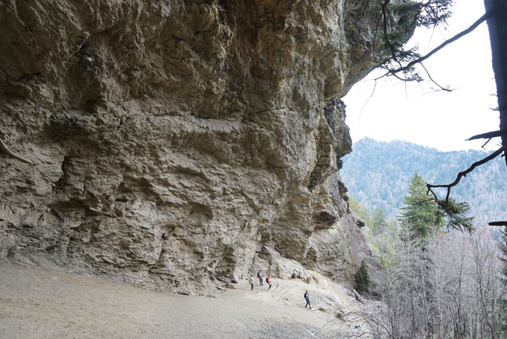
Under the circumstances, I honestly planned on spending the night on the mountain. It’s about 2.2 miles down to the Alum Cave, which while it isn’t really a cave, would still provide me with decent shelter for the night. It seemed like a reasonable goal in the daylight time I had left, and crucially, as it was a couple thousand feet down, would get me to warmer weather. And thus make the night not exactly comfy, but palatable.
It also meant I wouldn’t go stumbling off the edge of a cliff in the dark and to my ultimate demise. Which seemed pretty important to me at the time and even more so important now.
And so, I got moving. Faster than I’ve ever hiked. I double timed it, triple timed it and actually made pretty solid progress. But with each step, the daylight faded further and further and this, coupled with the fact that I was the only fool on the entire trail at this time, made the whole experience pretty spooky.
Well, I made it to the cave, and in a stroke of good fortune, the body heat did magically resuscitate the phone. Problem was it had ‘resuscitated’ all the way to 9% battery life. And given that I not only needed the light function but GPS too, I did not feel as though my circumstances had markedly improved.
So now I faced a choice.
Stay at the cave and wait it out till morning or stumble through the rest of as much of the remaining 2.7 miles as I could without the flashlight – then turn on the flashlight and hope it held out.
I chose the latter.
I made it about a 3/4 of a mile before I had choice but to turn on the light. Though I will say, it is somewhat remarkable how much your eyes adjust to the dark.
I kicked on the light and then kicked it into another gear.
Ever try navigating by iPhone light? It’s surprisingly bright for a phone and super handy to have, but I dare say that when Apple’s engineers put their collective super-brains together to build the thing, they did not necessarily intend it to be a navigational tool in the coal-like blackness of the Smoky Mountains.
Dark in the woods you see, is…real dark.
Ever driven home in a power outage and felt that eery dread as you navigate otherwise familiar territory? Ok, now kill your headlights, and all the ambient lights in your car. And all the lights for miles and miles and miles around.
So yeah, it’s real, real dark.
And my mighty phone tried her best, and I was SUPER happy to have her, but it’s not a headlamp.
With about a mile left to go, I was stunned that it was still on. With about 3/4 of a mile to go, I actually felt like I had a bit of a shot at this. The remaining portion of the trail according to the map was reasonably straight and more or less followed the river. And the river was to my left. So if the phone finally lost it’s battle with it’s battery, I was at least reasonably close to the trailhead, and could attempt to follow the trail in the dark by the sound of the river.
Remembering it was on my left.
Which sounds insane when I write it now, but seemed plausible at the time.
Turns out, I didn’t need it.
The battery held out. Don’t know how. But it did.
Got back to the car. And instantly realized that while I thought I was doing OK, I was actually pretty panicked. My legs were like rubber and my mouth felt like I’d swallowed a handful of sand. Probably not just due to my mental state but also the fact that I had all but run down 3500 feet over the course of five miles.
I composed myself for a few minutes. Got in the car and headed towards Gaitlinburg to find someplace to sleep.
I owe you all a story about the bizarro world that is Gatlinburg, TN, but that’s going to have to be an addendum. I’m zonked.
I’ll continue catching up over the next couple of days; because they’re going to be mostly driving days on the way to El Paso.
In the morning, I’m headed to Johnny Cash’s boyhood home in Dyess, AR and then through Arkansas, Southern Oklahoma and hopefully, North Texas.
https://www.alltrails.com/trail/us/tennessee/alum-cave-trail-to-mount-leconte
