| Durango, CO |
Canyonlands is an enormous National Park.
Encompassing over 337,000 acres, it’s the largest of Utah’s five national parks.
Southwest of my stay in Moab, it’s far less popular than it’s sister National Park, Arches and actually draws the least annual visitors among it’s peers.
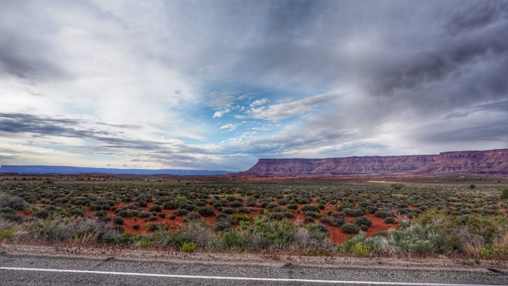
The drive to the Visitor’s Center, like many I’ve undertaken in the great Western expanse known as Utah is a lonely one, a long one and a lovely one.
Some 55 miles of two lane road and iron rich, red-cliffed glory surrounding you throughout.
So as I always do, I kicked back, enjoyed the pastoral setting and opened up the throttle; at least as much as you can truly open up the throttle in a Hyundai Veloster. (Hint: Which is to say, not much)
Eventually I came upon the road to the trailhead and in natural derring-do style, it was a dirt one.
Now if you’ve been following this journey, you’ll know that my compatriot Veloster and I have been down some ‘challenging’ dirt roads. Roads in which, quite frankly, my friend had no business driving upon.
She has performed more admirably than I could have possibly expected, but is often miscast in the role.
But as I had no intention of walking the 3 miles or so to the trailhead, off we went.
—–
As far as dirt roads go, this one was actually fairly well maintained. It wasn’t particularly rutted or rocky, and was mostly void of the moon-like craters that have often sought to swallow up my pea-shooter of a vehicle in the past.
That’s probably owing to the fact that this road resides in a National Park, and as such one would assume, got some more in the way of funding for maintenance.
But for what it made up in stability, it lacked, really, really lacked, in…..let’s say, a qualified engineer’s graceful touch.
It was as if the road had been engineered by simply laying it out on top of the existing terrain with no regard for the fact that, at some point, vehicles would actually have to drive on it.
Up and down, left and right, hairpin turns and blind curves…
No really, there were multiple signs on the road that advertised ‘Hairpin Turn’ and ‘Blind Curve’. And my personal favorite ‘Caution: Road Narrows’.
Narrows was a truthful description as at those points the road width reduced to just over enough for one vehicle, often while simultaneously coming to a blind rise or curve.
Now let me clear, I’m not a coward. Especially when driving.
I feel very confident behind the wheel and knock on wood, I’ve managed to drive some 6000+ miles on this trip with only a damaged windshield to report.
But…
When you come to a rise in the road and literally can’t see what’s over the top of the hill, or around the corner until the last possible moment, it’s bound to give even the most experienced vehicle operator a bit of pause. Especially when they are driving a clown car such as I have. (No offense my four-wheeled friend)
Well, as evidenced by the fact that you’re reading this, we made it.
Glad I am that we did, because I had a damn good hike ahead of me.
—–
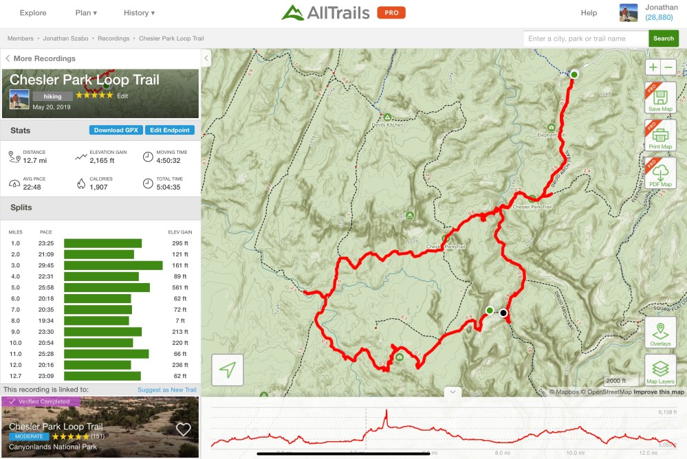
According to my trusty hiking guide, AllTrails, this was supposed to be one of the top treks in the park.
It also had some offshoots that would let me either extend or reduce the length as my legs saw fit – and I went into it with the goal of setting a new personal best, single hike distance.
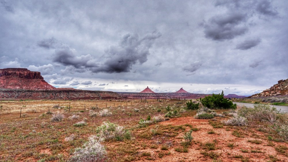
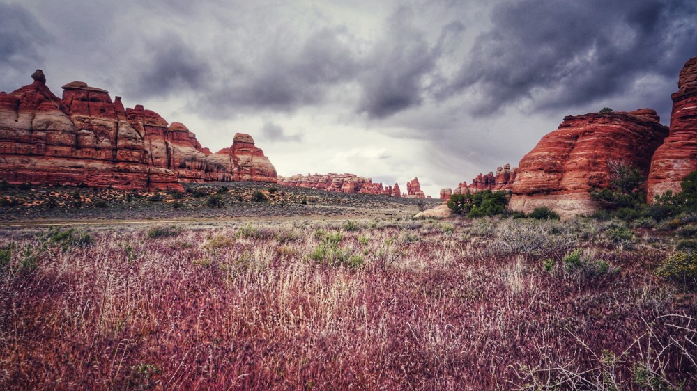
But for the fact that it looked like it might rain, the weather was really solid for hiking. Low 50’s and overcast. Not enough sun to make it too hot, and not too cool either.
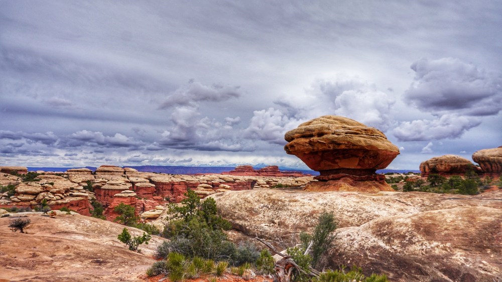
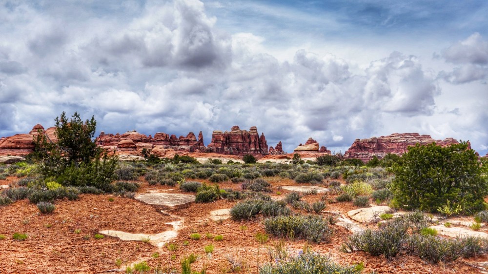
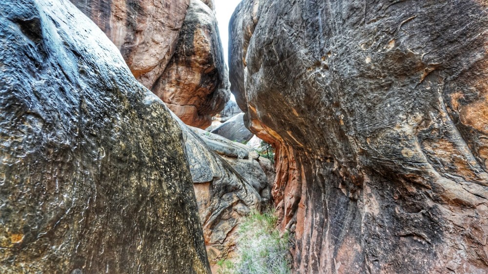
I’ll let the pictures tell the majority of the story of the terrain, but if you were to demand a brief synopsis of me, which would actually be your right as you’re the reader and I’m the writer, I guess I’d have to describe it as wonderfully weird.
A friend I met later in the day described it as like ‘something out of a Star Wars movie’, and it’s funny because I’d actually had the same thought myself earlier in the day.
The pictures will do it justice better than anything I can cobble together, but I will say that of all the sights I’ve seen on this trip, Mother Nature keeps coming up with bizarre ways in which to leave me amazed, astounded and very appreciative for all of her efforts.
The rock formations were completely unique and often looked like they were a recreation of a child’s imagination as brought to life by a Hollywood special effects artist.
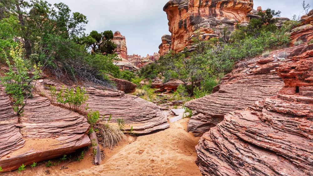
One thing I will say is that it is pretty damn amazing how nature finds a way.
You literally had trees growing out of the barest patches of soil, on top of solid rock. Other trees were seemingly growing straight out of the rock itself; roots splayed out in every direction seeking….no begging a chance at soil, at water, at nourishment, at life.
Give nature the tiniest chance at life and something is going to grow.
Most amazingly in the case of the lichens and such which grow directly on the rock and over time create their own soil, in essence eating the rock itself.
It’s something I’ve seen on many a hike, but something that will never ever, cease to amaze me.
—–
Primary navigation through this maze of rocky wonderland was through the use of a well maintained cairn system.
For those not familiar, cairns are an ancient system of navigation in which someone has piled some stones in top of each other.
Follow one pile of stones to the next, to the next and that’s how you follow the trail.
Elegant, somewhat ingenious in it’s simplicity and completely necessary in this environment.
For you often found yourself crawling between boulders, over bare slickrock and over even more bare enormous flat rocks that short of painting marks on the stone itself (heresy!) would have been otherwise impossible to chart a path on
Someone had done a rather amazing job in laying out this trail and despite all their hard work, I still got myself turned around a couple of times, eventually winding up back at a prior intersection of trails.
A little frustrated and having no desire to go back the same way I came, I huffed off in a different direction.
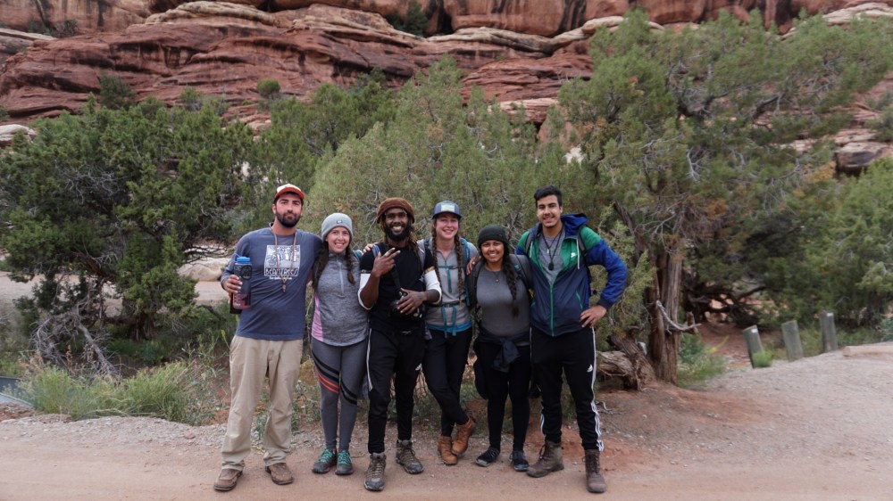
Getting a little huffy turned out to be a good decision as just a little way down the trail, I met my first group of great folks.
These two were an older couple, maybe late 60’s and it turns out, very experienced hikers.
Really nice people, we hiked and talked of our adventures and misadventures, their most recent conquests and my trip itself, before we parted ways after 40 minutes or so.
Though I mainly prefer the sanctity of hiking alone, meeting and walking with others on occasion adds an awful lot of nicety to the adventure.
And speaking of adventure…
—–
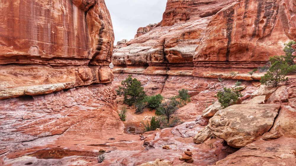
By far the most amazing part of this really amazing hike was the slot canyons!
Slot canyons are narrow, in this case very narrow traverses in which you navigate, well a canyon.
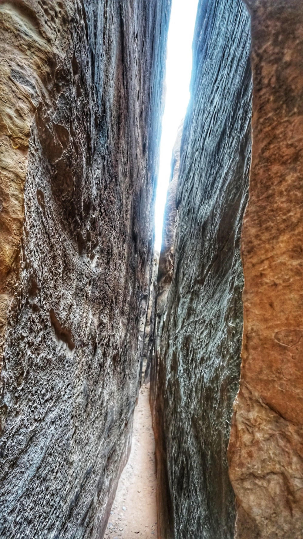
Here you were hiked or crawled into spaces literally shoulder-wide while surrounded my massive boulders on your left and right. Some of which were well over 100 feet high.
I’ve had some experience with slot canyons, but absolutely nothing like this. Not only was the depth of the canyons extraordinary, but the length and breadth as well.
They continued on for probably close to a mile I’d guess and at multiple points I found myself drying off from the rainstorm that had kicked in, because no rain would penetrate that deep into the canyon.
A really surreal experience and definitely one of the coolest parts of this trip.
And speaking of cool parts of the trip… 🙂
—–
About halfway through I faced a choice as to going the long way, or cutting the hike significantly shorter and heading back to the car.
The wind had really kicked up, it had gotten cold and then started to rain, and I was a little worried that if the rain really started coming down, I was going to have a very hard time getting back up that dirt road.
But I went on and eventually after hiking through some incredible grasslands, came upon a group of folks standing at an intersection looking very lost.
Turned out the weren’t exactly lost, but they definitely weren’t exactly found either.
They’d hiked in a different route from the same parking lot as I, were looking to get back, and were a little unsure how to do so.
I had the advantages of my digital map. They had a paper one. And as is most often the case, digital wins.
We joined up. I took point, proudly exclaimed something like ‘follow me’…
…And then I proceeded to hike the seven of us 2/10’s of a mile in the wrong direction.
Sigh…
—–
Collective navigation got much better after that and they turned out to be a really, really wonderful group of folks.
We hiked the last four or five miles out together while talking about where we were from, my trip and recent ‘retirement’ from GEICO, their adventures – of which they were many! – and a variety of other topics as well.
We had a mutually symbiotic relationship as I helped them with navigation and they helped me keep my pace up, while allowing me to partake in one of my favorite recent pastimes, the art of conversation.
I’ve met a lot of people on this trip and thoroughly enjoyed our time together as much as I have any other one. Probably more.
I’ve talked about this in prior journal entries but remember that us coming together was completely random.
Dre and I were talking about that general topic at one point, I said I’ve never been a believer in ‘fate’, he agreed, and then coined the term, ‘happy coincidence’ and I thought that wholly appropriate.
In the end we exchanged a few high fives, a group chant and contact information.
They went off to their campsite for the night as I waved goodbye and I, tremendously enriched by the entirety of the experience, drove off alongside the setting sun.